

Hikes November 2021–March 2022
This installment covers hikes from the past several months. We were in Arizona for a week in November and did a couple of hikes in Saguaro National Forest. In late January/early February, we went on a short road trip to the Leavenworth area and did some snowshoeing. The last couple of snowshoe hikes were in the Seattle area.
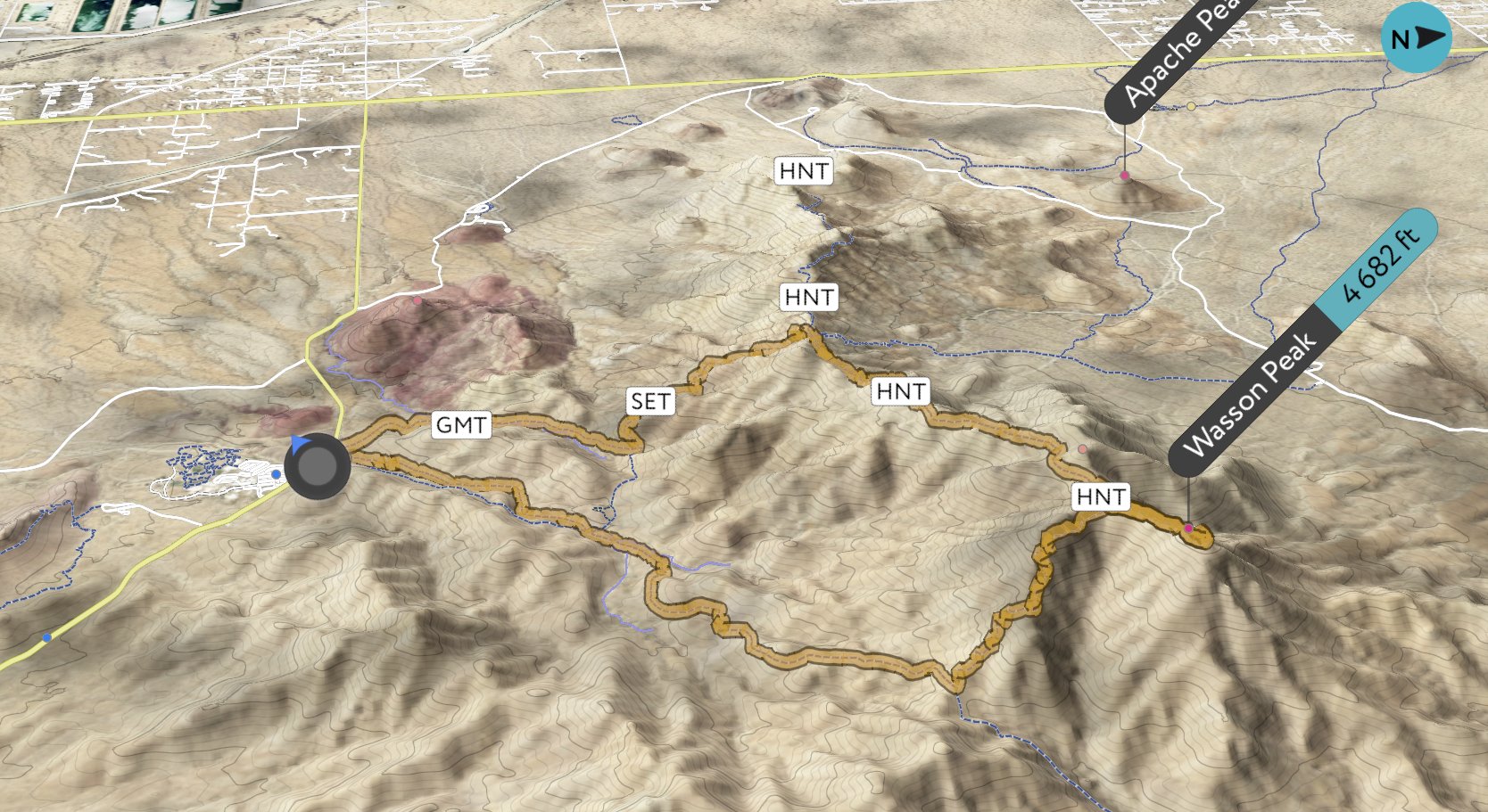
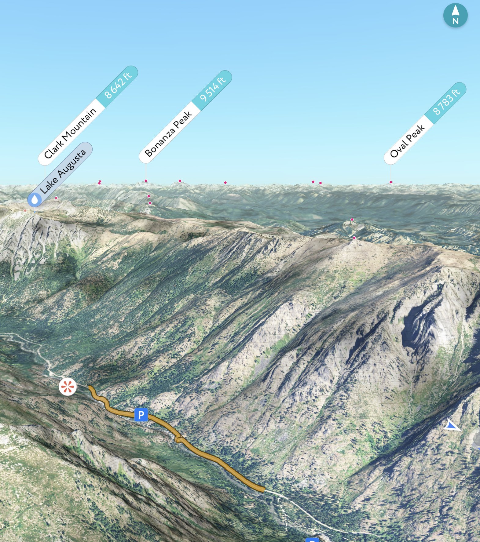
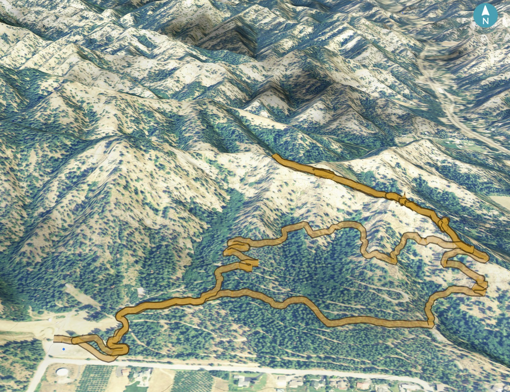
The image of the hiking track shows is a 3D rendering, with our route in orange (the grey/white circle with the blue arrow is our starting point). The graph shows our altitude (the top one) and our pace (the bottom line). It also shows both distance (white numbers at the bottom) and where we were at the various hour markers (black numbers at the top).
Douglas Spring Loop, Saguaro National Park
7.2 mi, 1,100 ft gain
8-Nov-2021
Saguaro National Park is divided into two main areas. For our first hike, we went to the east side. There are a lot of trails, but we followed the route suggested by AllTrails which goes out to Bridal Wreath Falls.
The start of the Douglas Spring Trail is level and covered with saguaro cactus, which you can't miss because of their size. We also saw a lot of barrel, cholla, ocotillo, and prickly pear. We saw what looked like low hills in the distance, but before we knew it, we started climbing.
Looking out at the landscape as we gained altitude, it was striking how different it looks from the evergreen forests we're used to. We could also see quite far away since most of the land was flat.
The map showed that we would cross a river bed, which we did. Since it wasn't the rainy season, the bed was dry. We were more sure than before that we would see where Bridal Wreath Falls would be but would see no water actually flowing.
As we got higher, the landscape changed to have more shade from trees such as mesquite. The last part of the spur we were on to get to the falls was a little trickier to follow, but we found the trail again and followed it to the falls. We came to the lower falls, and because it was dry, we walked on the boulders right up to where the base of the falls was. It was easy to imagine what it would look like with water, but then we wouldn't have been able to get as close as we did.
We started backtracking a while before continuing on our loop, picking up the Three Tank Trail, losing altitude. We crossed another river bed several times before coming across an old, rusted tank (just one, not three). One final crossing of the river bed, over a small rise, and we were on Wildhorse Trail. After that, we came across an intersection with the Bajada Vista Trail and the one we took, the Garwood Trail. We took that until it stopped when it met back with the Douglas Spring Trail, which we took back to the parking lot.


Wasson Peak, Saguaro National Park
7.5 mi, 1,800 ft gain
10-Nov-2021
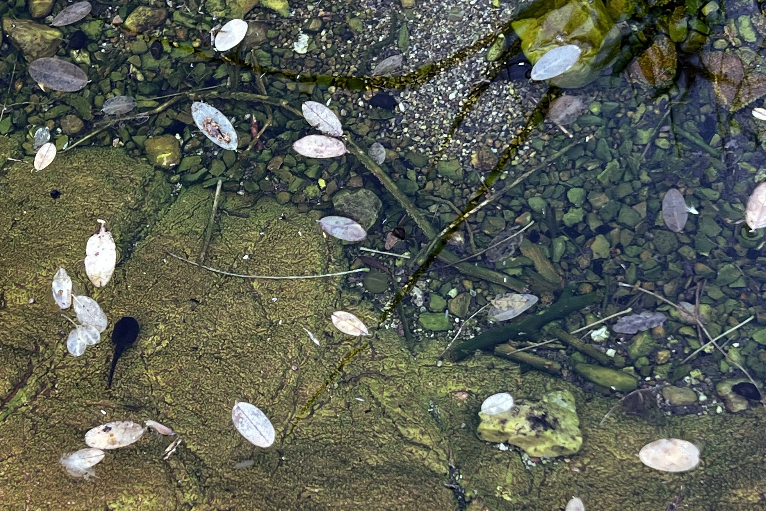
Having already done a hike in the eastern part of Saguaro National Park, we headed to the west, which is more mountainous terrain. We had no trouble finding the parking lot, but right at the trailhead, we had a decision to make. We could either start on the trail or go down into the wash, which has petroglyphs. It was an easy decision.
As we descended into the wash, it was easy to see just how much water could be going through in the rainy season. As with the river beds we saw in the eastern part of the park, the wash was dry. After we had gone a little way, we saw a small toad. Thinking it was an odd place for it to be, we soon saw a small pool of water and even saw tadpoles swimming around.
We kept a lookout on the walls of the wash for the petroglyphs. There were several places where we had to step up and one part where we had to find a path up to a ledge about 10–12 feet above us. We could imagine the waterfall during the rainy season.
Near the point where we were going to exit the wash, we saw a few petroglyphs and stopped to look, not realizing just how many we would see as we went along. They were very striking to look at.
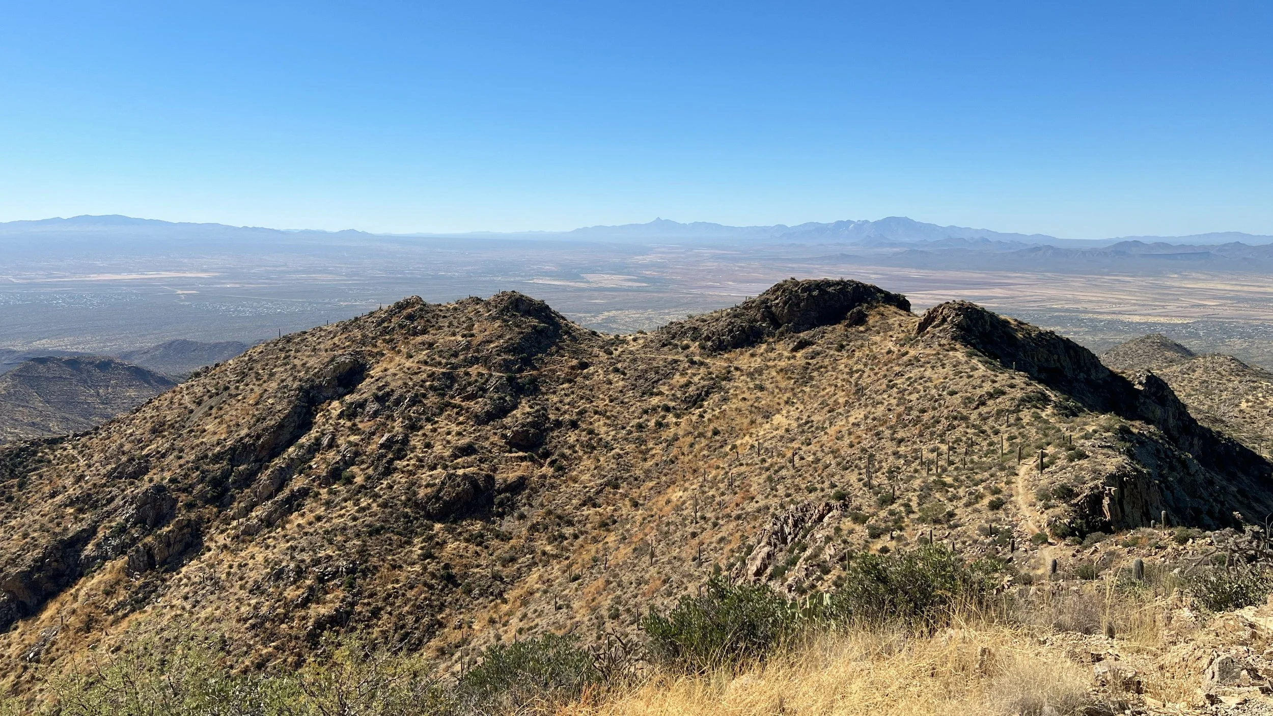
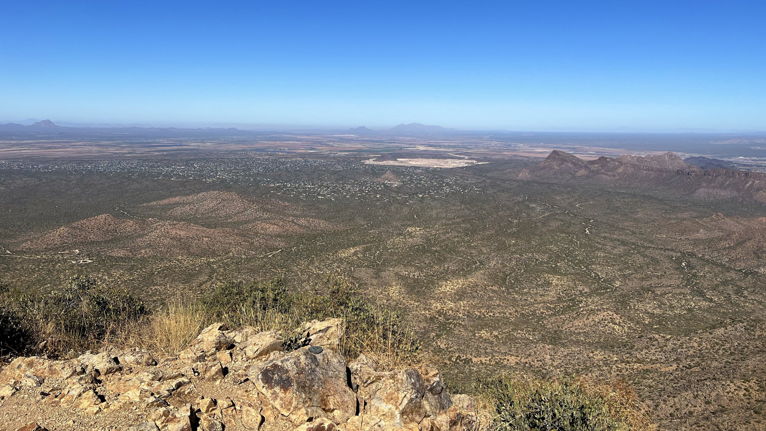
Out of the wash, we soon started climbing. Wasson Peak looked pretty far away, but we soon started going directly towards it. Switchbacks had us gaining altitude in earnest, yielding better views of the Tucson area. We were also able to look down and see the trail we had taken up.
We finally got to the part where we went along a spur across a ridge to the final climb to Wasson Peak. At the peak, we saw a raven flying around, at times almost still with the wind.
The views at the peak were great, and we found a place to have lunch. As we were finishing up, a hawk was flying around. The raven must have gone away.
Time to go back to the trail to continue the loop. As we got past the ridge, we started chatting with a couple who ended up being from Olympia, WA. They said they spend time in Tucson every year and have done quite a bit of hiking in the area. As we got close to the loop, we saw that they had reached the peak.
We had already done the short, steep part of the loop, so it was time for the longer part. The trail seemed to keep going down, and it was hard to tell when it would start heading back to the trailhead. There was finally a small gap on a ridge that took us to the other side, and we started seeing large bunches of cholla all around and on the hill above us.
Further down, we saw parts of an abandoned mine. We walked up to what looked like a ventilation shaft. Near that was a tailings (what's left after the ore is extracted) pile from the Gould Mine. After that, it wasn't too long before we were back by the road, and went back into the wash for a short trip back to the trailhead.


Pipe Creek Loop, Blewett Pass
4.25 mi, 1,050 ft gain
31-Jan-2022
On our way to Leavenworth, we went across Blewett Pass to do a snowshoe trail there. We had done some of the trails the year before, all from the main SnoPark. This time went to a different parking lot. We weren't sure how many people would be there since it wasn't particularly early, but there were no tire tracks going to the lot. We parked next to another car that had been there a while, buried in snow. One of the recent trip reports reported the car that day, too.
Since we were the first ones in the lot, we figured we would be the first ones on the trail, and that was indeed the case. The first part somewhat follows the road until you turn off and cross Swauk Creek. After that, the climb begins.
Not having previous tracks to follow made wayfinding a bit trickier than usual. We knew we were at the start of a loop but were trying to figure out which direction was what, finally settling on the far left fork to go clockwise. The live map eventually showed we were going counter-clockwise after all. We figured we must have missed the turnoff on the left.
Content to go counter-clockwise on the loop, we started climbing in earnest. There was a bit of snow falling, somewhat lowering visibility, but at one point we had a peek-a-view look at Diamond Head not far to the east.
As we finished our loop around the hill, we saw where we had missed the turnoff to go clockwise. It was pretty obvious since we were still the only ones on the trail, so our tracks were quite obvious. We found a place to have a late lunch, then followed our tracks back to the car. We were surprised at how steep the trail was going down since we knew we were working but hadn't realized how steep the trail was going up.
We got back to the trailhead, loaded up, and waved goodbye to the buried car.


Icicle River Road, Leavenworth
3.5 mi, 220 ft gain
1-Feb-2022
Since we had gained quite a bit the previous day, we opted for a relatively level trail. Icicle Road is at the west end of Leavenworth, and there's a parking lot where plow stops. Beyond that, the road follows Icicle Creek and is available for all uses. While we had snowshoes, we also saw people cross country skiing and even just hiking with boots.
At the very start of the trail, we saw several snowmobiles parked along the side. We didn't see any being used that day, but it could be they are mainly used on weekends.
A few other people were on the trail, which wasn’t surprising given its popularity. We were in a canyon with the creek next to us on one side and cliffs with icicles on the other. Easy to see how the creek and road got their names.
We intended this hike to be less stressful, so we turned around before too long and worked our way back. We had gone by a huge boulder on the way out and made a note to go on the other side by the river on the return trip. It ended up being a good place to have lunch. After that, it was not too far to the car.


Ski Hill, Leavenworth
4.75 mi, 1,030 ft gain
2-Feb-2022
The previous day's hike was supposed to be less strenuous. On this day, we weren't sure what to expect. Since it wasn't the weekend, the lifts weren't running. As a result, there were few cars in the lot. We didn't have a lot of information in the form of live maps, but there was a PDF that we used to get a general idea of where the various trails went.
We started off, and fortunately, the signage was pretty good. It took a while, however, to figure out the scale. Once we did, we were on our way. After getting past the cross-country ski trails and going downhill a little bit, we started to climb, and it seemed to keep getting steeper. We kept looking back at the town, and it seemed that more was visible to us with every switchback.
We got to an intersection where we could choose between three different paths. We chose one that seemed to go for a while and then loop back towards the entrance. We were the first people on that trail for the day, and as we got higher, the snow got softer, making it harder to break the trail. We got to a peak, gawked at the town below, then went up to a higher peak. Looking at the map and considering we would have to continue breaking trail, we chose to double back to the big intersection and take the lower trail.
We saw some bike tracks on this trail, so we figured the going wouldn't be too bad. We found a place to have lunch, then continued down the hill, returning to the cross-country ski trails. We figured we were good for the day.


Chiwawa Rock Ridge Trail, Lake Wenatchee
3.5 mi, 750 ft gain
3-Feb-2022
On our way out of Leavenworth, we went up near Lake Wenatchee to a trail we didn't make it to last year. There were a few cars in the lot, so we expected to see other people on the trail.
This trail is like a lollipop with a small loop on the stick. There's a bunch of climbing to get to the first, lower loop. Once we were past that, we didn't see fresh tracks, but it was still easy to make out the trail.
The first part of the upper loop was flat or even a bit downhill, but it got steeper once we got around the far end. When we got to the top, we started seeing ski tracks, thinking someone was pretty adventuresome. As we started down, the ski tracks eventually wandered off into the trees as we continued on the trail.
The trail map showed some glacial erratics, and our route down the hill took us right by them. They were indeed large but mostly covered with snow.
We thought it was time for lunch, so we found a place to do so. We knew we were pretty close to the car but decided to enjoy the scenery in the trees where we had stopped. After that, it was a short way to the car and the drive home.


Easton Reload, Snoqualmie
2.25 mi, 100 ft gain
4-Mar-2022
This was the first of two snowshoe hikes on the same day since they were short. The first was the Easton Reload, a trail that opened in 2021 to help ease the congestion on other trails. Because it's so new, we didn't have any live maps but did have a photo of the map at the trailhead.
Almost immediately after we started out, we needed to cross a stream. There was no structure to cross, only a few stones. We figured our boots would get wet, so we just went for it. After getting our snowshoes back on, we started following what looked like the trail but quickly ended up at a dead-end, so we turned around and found it as we went the other way.
After a while, we came across another river crossing. This one had a few logs, but they were too low to support us over the water. We already had wet boots, and they didn't get much wetter, but we hoped there wasn't another river crossing (knowing that we already would be doing two crossings on the way back).
Wandering a bit more, we got to the end of the trail. We decided to follow the river for a little longer and came up to a wide, open field. We decided it was a good place to turn around.
Since we had wandered off the trail, we followed our own tracks back to where we left it. We did our two river crossings and made it back to the car. We hadn't gone very far (even with the part we added at the end of the trail) so we decided to find another trail.


Cabin Creek South Loop, Snoqualmie
3 mi, 350 ft gain
4-Mar-2022
After leaving the Easton Reload, we went one exit on the freeway and started looking for a place to park at Cabin Creek. The lot was pretty full, so we went a bit further to a secondary lot which was pretty empty. We needed to go over a berm that was probably about 8 feet high to reach the trailhead, then we started out.
Once again, we seemed to be the first snowshoers since the last snow, but we did see tracks left by a cross country skier which we tried to not stomp on.
This trail goes around a hill, with a spur to go to the top. The route we chose would have us going almost all the way around before working to the peak, all uphill. After not quite a half-mile, the Yakima River came into view, and we decided to stop for lunch.
Once we had our snowshoes back on, we continued our gradual uphill trip around the hill. About a mile from the trailhead we turned onto the spur to go to the top of the hill. We had been breaking trail, and continued to do so on the way up. It was a bit of work, but we did make it to the top. Unfortunately, there wasn't a great view through the trees, but we could see the skier had tried going up as high as possible.
After returning to the bottom of the hill, we decided to double back instead of continuing around. It would be further, but we would avoid needing to walk along the road. In addition to being downhill, we followed in our own tracks, so that part was less work too.
We made it back to the trailhead, found our way down the berm, and switched to dry socks and shoes before heading home.


