

Hikes - July/August 2020
We took a few hikes in July and August, with a couple along Highway 2 and another near Mt. Rainier. They were each more challenging than the first two hikes of the season.
The hiking track tracks my heart rate, so the closer to red, the higher my pulse. The graph shows our altitude (the top one) and our pace (the bottom line). It also shows both distance (white numbers at the bottom) and where we were at the various hour markers (black numbers at the top).
Lake Serene
Lake Serene and Bridal Veil Falls—19-Jul-2020, 9.1 miles, 2,620 feet gain
We knew that Lake Serene would be pretty challenging for us, especially since we wanted to do the extra bit to see Bridal Veil Falls. Figuring we could take it slowly when we needed to, we headed out.
Leaving relatively early, the parking lot was still full when we got there, but there was an overflow area nearby which was empty. As we got to the trailhead, there was a phone number you could text with how many cars were in the lot, so I just said that the lot was full. There were follow-up questions, but since we had already started out by the time I got the first response, I waited until afterward to finish the survey.
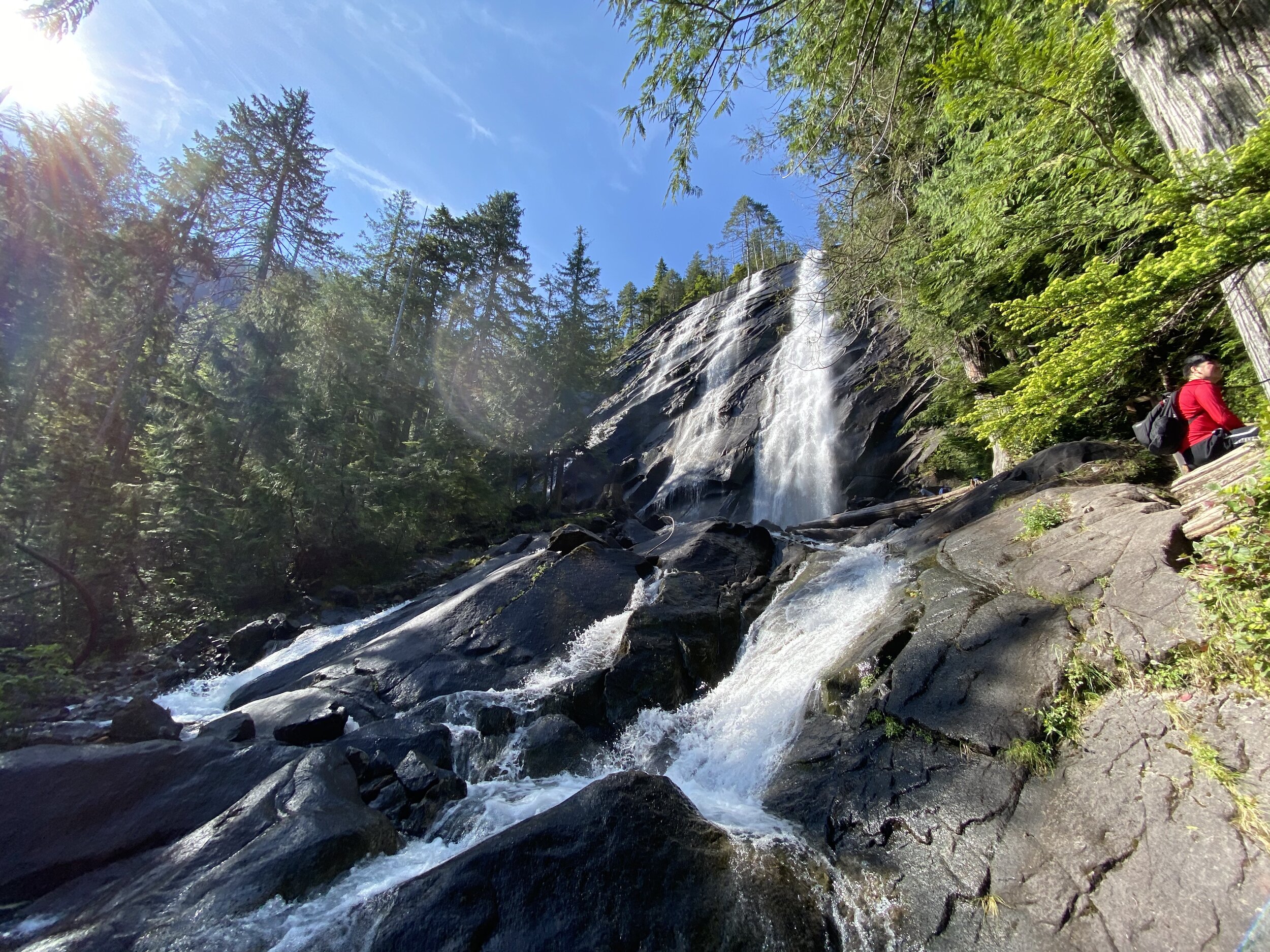
If you look at the elevation map and my heart rate on the tracking map, you can see that the hike started out not too steep until we made the turn to go to Bridal Veil Falls (the spur about halfway down the tracking map). Once we made that turn, there began to be large segments of the trail that were stairs. Fortunately, there was enough room to pass other people.
When we got to the lower falls, we had a pretty good view, but knowing that we wanted to go to see the upper falls, we went on up. There were only a few other people there, so it wasn't a long wait to get a really good view. On the way back down, we took a better look at the lower falls, then wove back down the stairs to the main trail.
Looking again at both of the maps, you can see that the trail got pretty steep, with a large part of it going up stairs. It was quite strenuous, so we took several breathers before continuing up. Once we got over the ridge, we went down slightly to get our first glimpse of Lake Serene. We crossed the inlet across a footbridge which was narrow enough to have a handrail on one side. There were several people there already but it was easy enough to find a spot on a huge rock to have lunch without feeling crowded.
Across part of the lake, there was another huge rock with a bunch of people on top. We heard a splash, so I got my camera out to try to take a look, and saw someone else jump in. Waiting a few more minutes, another swimmer went in (looked like one of the people who jumped in before) and I was able to get photos of her.
We were quite tired, so took it pretty slowly on the way back. Several groups passed us, and several others were going towards the lake. Obviously, we opted to not go back to the falls on the return trip.
This hike ended up being a stretch for me only having done a couple of other hikes this season, but it was doable. We did go through all our water. It's not as bad as it sounds; we knew we were close to the end, so went ahead and finished it off.
Since we were along Highway 2, traffic was quite heavy on the way back; it took quite a bit longer to return than it did to get there.


Lake Valhalla
Lake Valhalla—2-Aug-2020, 8.6 miles, 1,830 feet gain
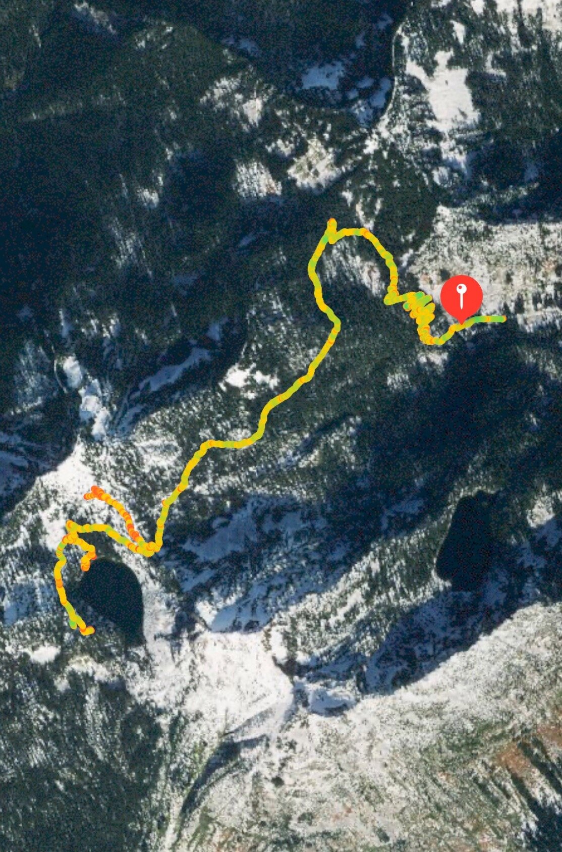
We deliberately chose a hike that was less challenging than Lake Serene. Lake Valhalla ends up being only a bit further along Highway 2, so it was a familiar route to get there. Once again, the parking lot was full, but there was plenty of space along the pothole-filled Forest Service road; the red pin on the map is the trailhead, and the track to the east is where we parked. There was a register, so we signed in, then started out. Unlike Lake Serene, the steep part was at the beginning with several switchbacks, so our legs were much fresher than having to do steps towards the end of the hike.
Part of the trail is along the Pacific Crest Trail (most people know it from either the book or movie, Wild) which tends to be pretty well maintained and not too steep.
As we were getting closer to the lake, we were going to try to catch a side-trail up Mount McCausland (just north of Lake Valhalla), but we had trouble finding it. We ended up going past the access trail to the lake and instead going around it, up on what looked more like social (non-sanctioned) trails around the west side of the lake. We figured we had gone too far for it to be the side-trail we were looking for, so we stopped to get a view of the lake, then doubled back down to the lake itself to get a different viewpoint and have lunch.
There were quite a few people down at the water, but since we were a bit above them, we were able to find an empty area. After lunch, we did make our way down to the beach where there were quite a few more people.
On the way back, we found the trail up Mount McCausland, so we started our way up (it's the part of the track that goes to the north of the trail). That path got quite steep, and since the dirt was very loose, we decided to turn around before getting to the top (which was the location of an old lookout). Even so, we could see the whole lake; it was a dramatic view.
We worked our way back at a pretty quick pace, got to the car, and drove back home. Once again, Highway 2 was quite slow, at least we knew to expect that.


Crystal Mountain
Crystal Mountain—23-Aug-2020, 8.2 miles, 2,175 feet gain
Instead of going on a hike along Highway 2, we decided to go near Mt. Rainier. The Crystal Mountain ski resort has a few trails, many of which hook up to the Pacific Crest Trail. It was strange to park in such a large, well-maintained parking lot which was easy to find a spot in, but we got over it.
The trailhead was right next to the parking lot, but once you pass the sign, it's quite steep until you get to the actual trails. Once we got to where the loop began, we ran into our first conflict of the hike; the map and trail description I had on the phone (same as the link above) takes the loop counter-clockwise, going through Bear Gap first and then into Bullion Basin. We also use a text description, and that described going clockwise. Since it would be easier to find our place on the map than trying to go through text backward, we went to the left.
As you can tell by the elevation graph, the peak was about 3 miles into our 8-mile hike, so the way up had some pretty steep parts. While we were on the early switchbacks, we let a few horse riders go by.
We made it to Bullion Basin and took a couple of minutes to take a look around. After that, the path got steep again; we realized that we were completely off the map on the phone. I had downloaded the USGS map which did have the trail we were on, so we had an idea of how much further we had to go before we got to a good viewpoint. The group on horses was finishing up and ready to head back, so we wished them well as we took in our first good views of Rainier and sat down for lunch.
After we set out again, we did a few switchbacks and met up with the Pacific Crest Trail, which we followed for quite a while along a ridge near the Pickhandle Gap. We saw Rainier ahead of us until we started to go around Pickhandle Point, getting to Bear Gap. When we got to the intersection where we would leave the PCT, there were several people resting there, including a bunch of mountain bikers. Since the riders were going the same way we were, they went ahead; while they were getting ready, we took a quick detour to take a look at the views there.
We continued going down towards Hen Skin Lake, which was larger and more interesting than it seemed it would be on the map. There was an older couple there wandering around, looking for a good log to sit on and enjoy the view. As we left the lake, we saw a half dozen or so people, several with kids in carriers, heading to the lake, hoping they wouldn't interrupt the couple too much.
The going became pretty easy for the last couple of miles, as you could see by the time graph. Having gone by a couple places with Pickhandle in the name, we figured there must have been mining in the area, and indeed, we saw an abandoned mine entrance.
We knew we were close to the end when we saw the chair lifts. After closing the loop, we worked our way down the hill, feeling pretty tired. On the way back home, we stopped at a store to get some ice cream; the wait was very long, but it was a good way to punctuate the trip.
This hike was pretty difficult, but not as much as Lake Serene, which was steeper and towards the end, not to mention adding Bridal Veil Falls added a lot of gain.


